Monitoring and Evaluation of Flood Damage Using Radar Remote Sensing and Google Earth Engine: Case Studies of The Kon and Ky Lo River Basins, Vietnam
In recent years, the South-Central Coast of Vietnam has frequently experienced severe impacts from heavy rainfall and tropical depressions, leading to increasingly frequent and intense flooding. As a result, widespread inundations have occurred in the downstream areas of the Kon and Ky Lo river basins, causing significant losses in both human lives and property. In this context, monitoring and tracking flood dynamics remain challenging, especially under complex stormy weather conditions.
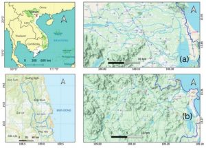
Figure 1. Location of the Kon River basin (a) and the Ky Lo River basin (b)
With the recent development of radar satellite technology, particularly Sentinel-1 operated by the European Space Agency (ESA), flood monitoring has become more efficient and practical compared to using optical remote sensing imagery, which is limited by weather conditions and cloud cover. In addition, the advent of the Google Earth Engine (GEE) platform has greatly facilitated the integration and processing of Sentinel-1 imagery, overcoming the limitations of conventional software that often require high computing capacity and large data storage.
To assess the historical flooding and develop a future flood forecasting tool, Subproject No. 1 of the IUC project a collaboration between Quy Nhon University and KU Leuven, integrated Google Earth Engine (GEE) technology with Sentinel-1 radar satellite imagery to analyze flood risks. In this study, the severe historical flood events of 2016 and 2021 were considered. The results were validated against field-surveyed historical flood marks. Accuracy assessment indicated that the flood maps provided high reliability, forming a basis for effectively detecting flood-inundated areas from satellite imagery using the GEE platform in future applications.
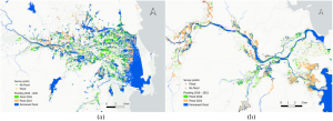
Figure 2. Flooded areas identified during the period 2016–2021 in the (a) Kon River basin and (b) Ky Lo River basin
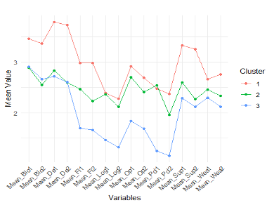
As a result of the extraction process, the research team analyzed the flood events and found that in 2016, the Kon River basin experienced widespread flooding, whereas in 2021, the Ky Lo River basin was more severely affected. Furthermore, by integrating the analysis with a Digital Elevation Model (DEM), the research developed flood depth maps and classified flood-prone areas according to inundation depth. The classification results indicated that high flood-risk zones accounted for more than 25% of the total basin area.
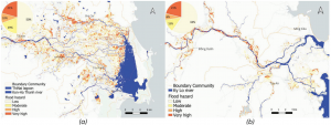
Figure 3. Maximum flood depth during the period 2016–2021 in the (a) Kon River basin and (b) Ky Lo River basin
By combining flood data with land cover information, the research team analyzed the affected areas and found that rice cultivation was the most severely impacted, as the floods typically occurred at the end of the year coinciding with the winter–spring sowing season. The results were cross-checked with damage reports from the Departments of Agriculture and Environment of Binh Dinh and Phu Yen provinces (currently Gia Lai and Dak Lak), showing a high level of consistency and reliability.
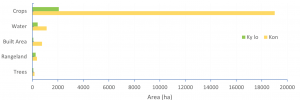
Figure 4. Flood damage levels for selected land-use types in the Kon and Ky Lo river basins
This study was presented by the research team at the EGU 2024 Conference in Austria and at the National GIS 2024 Symposium, and later published in the IOP Conference Series: Earth and Environmental Science, indexed in Scopus [1,2].
Through this research, the team aims to provide valuable insights for local authorities in enhancing flood mitigation efforts, land-use planning, and disaster response strategies to improve resilience and reduce future flood-related damages. In addition, the results serve as a reliable dataset for validating hydrodynamic models and as input data for machine learning models to predict future flood risk zones within the basins.
References
[1] Van Phan, T., Anh Ngo, T., and Willems, P.: Historical Flood Mapping Combining Radar Remote Sensing and Google Engine Technologies for The Kon and Ky Lo River Basin, South Center Coast Vietnam, EGU General Assembly 2024, Vienna, Austria, 14–19 Apr 2024, EGU24-4056, https://doi.org/10.5194/egusphere-egu24-4056, 2024.
[2] Van Phan, Tho, Patrick Willems, and Tu Anh Ngo. “Flood Mapping and Damage Assessment in Vietnam’s Kon and Ky Lo River Basins using Radar Remote Sensing and Google Earth Engine.” In IOP Conference Series: Earth and Environmental Science, vol. 1501, no. 1, p. 012005. 2025.